
 Update: 01-03-2025


After the 1829 Inspection Voyage to the West Coast, the Engineer, Robert Stevenson, recommended to the Northern Lighthouse Board that a Lighthouse be erected on Barra Head. The Commissioners approved the recommendation and preliminary reports were prepared early in 1830.
Barra Head, also known as Berneray (Scottish Gaelic: Beàrnaraigh), is the southernmost of the Outer Hebrides in Scotland. Within the Outer Hebrides, it forms part of the Barra Islands archipelago. Originally, Barra Head referred only to the southernmost headland of Berneray, but is now a generic name for the whole island. The highest point on the island is Sotan.
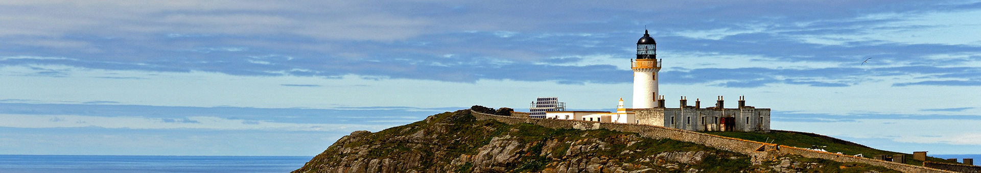
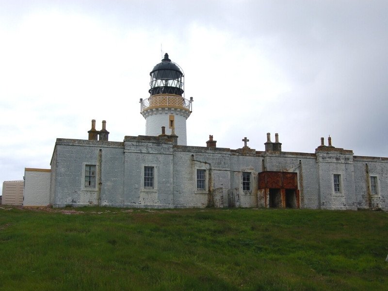
Barra Head Lighthouse is the most southerly lighthouse in the Outer Hebrides and is the highest placed lighthouse in the UK. Barra Head Lighthouse is built high on the top of the southerly island of Berneray. The steep cliff on which the lighthouse stands is about 200 meters high, and the height of the light is 280 meters. There is a climb from the shoreline of approximately 2 kilometers to the lighthouse.
The site was chosen for several reasons; because Barra Head is roughly half-way between Eilean Glas and Rhinns of Islay Lighthouse and it stands at the Southern entrance to the Minch (The strait between the Inner- and Outer Hebrides). It would also be of great assistance to the coastal shipping off Argyll and to foreign-going vessels approaching the West Coast of Scotland.
There is no shallow water west of Berneray to break the gales of the Atlantic and sometimes small fish are thrown onto the grass on the cliff. In 1836, Sir Archibald Geikie recorded the movement of a 42-ton (43-tonne) block of gneiss over 5 feet (1.5 m) of ground during a violent storm.
Building of the Lighthouse
The lighthouse was built by James Smit of Invernee under the supervision of Robert Stevenson. Stevenson reported in 1831, during construction, that 'little work can be done here except in the summer months. Access to Barra Head is found to be extremely difficult, maintaining communication by post "currently requires an open boat crossing of 100 kilometers (54 NM) from Tobermory". The light of the lighthouse was first lit on October 15, 1833. That was the same time that the Lismore and Girdle Ness Lighthouses were first lit.
The last inhabitants left the island by 1931, leaving only the lighthouse keepers and their families. The lighthouse keepers left the island 23 October 1980 after automation. The fourth order optic was moved to the Calf of Man Lighthouse in 1994.
When the last few farming families left the island, the Northern Lighthouse Board proposed a wireless system to Barra Head and could make direct contact with the shore in Castlebay op Barra. Like Lismore, Barra Head was a family station. That meant that the lighthouse keepers lived on the island with their families.
Due to the hazardous landing conditions, Barra Head Lighthouse was classified as a "Rock Station" by the NLB. Two small boats had been swamped and lost in the enormous swell by the slipway at the landing place. The regulations associated with this change prevented both alongside landings by tenders and the lighthouse men keeping dinghies onshore. From 1952, the keepers' families were housed in one of the new villas at Oban's coastal station.
Barra Head is a small wedge-shaped island 3 kilometers long and 1,3 kilometers wide. The ground is mostly rocky and it covers pretty much the whole island. There are no valleys for farming; there isn’t a suitable bay or way to approach it. The sea bed in the west varies in depth between 120 and 150 meter. While the sea floor on the other, east side extends for 50 kilometers going down up to 400 meters. The best host is the north side, as it offers two small landing places, Leac na Fealia and Achduin. From these two jetties a path leads west and up the hill across the highest slope on the island and straight to the lighthouse.Warning systems (Light, Fog horn)
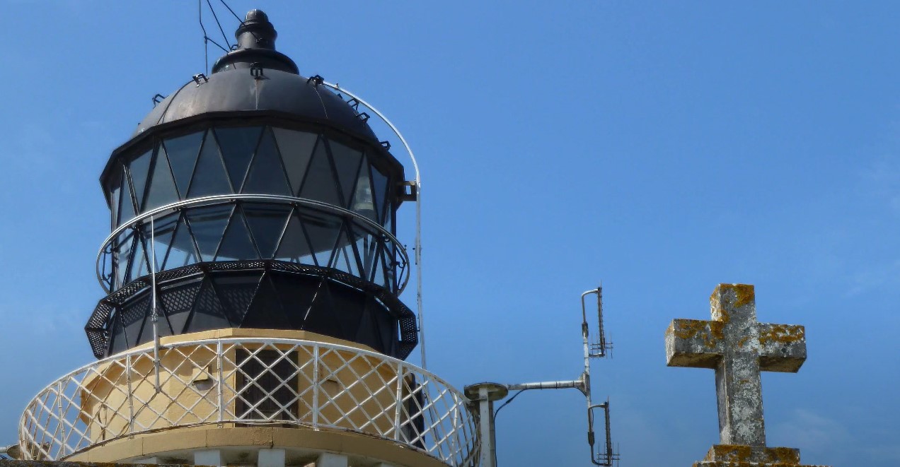
The oil lamp originally placed in 1833 was replaced in 1906 by a light bulb. In 1978 this system was replaced by an Acetylene (Dalén) system and converted to automatic operation, which was put into service on October 23, 1980. In 1993 a return to electric lighting of the lighthouse was made and a Pharos Marine PRB46 Sealed beam was installed. Electrical power is provided by batteries and Solar panels.
Additional information
A stone cross is located in the rear facade above the former lighthouse keepers cottages. This is the only lighthouse in Scotland believed to have this feature. An archway behind the array of solar panels leads to a headland that looks straight down onto vertiginous cliffs. Puffins, guillemots and razorbills circle and dive here.
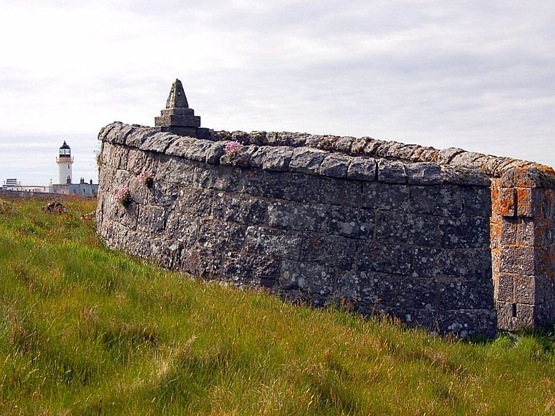
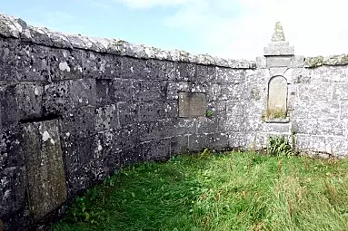
Beyond the lighthouse is a small circular enclosure, now overgrown. A number of memorial plaques are embedded in the walls. These plaques are dedicated to young children of the lighthouse keepers, who had died there on the island. The island is so remote that it was difficult to get emergency treatment in an emergency.
After the last war, the remains of a Blenheim bomber were found on the cliff face. The parts found enabled the Blenheim and crew to be identified. Apparently, it had crashed in a storm and no-one had heard it.