 Update: 01-03-2025


Brough of Brisay is a small tidal island on the northwest side of mainland Orkney.
This special tidal island is accessible via a causeway (concrete dam). On the east side there are Pictish, Norse and medieval remains to explore, as parts of Norse houses, barns and even a sauna can be discerned. A small church and a monastery were later built on Birsay.
The lighthouse is located on the west side of the island on Brough Head and at the east side are the remains.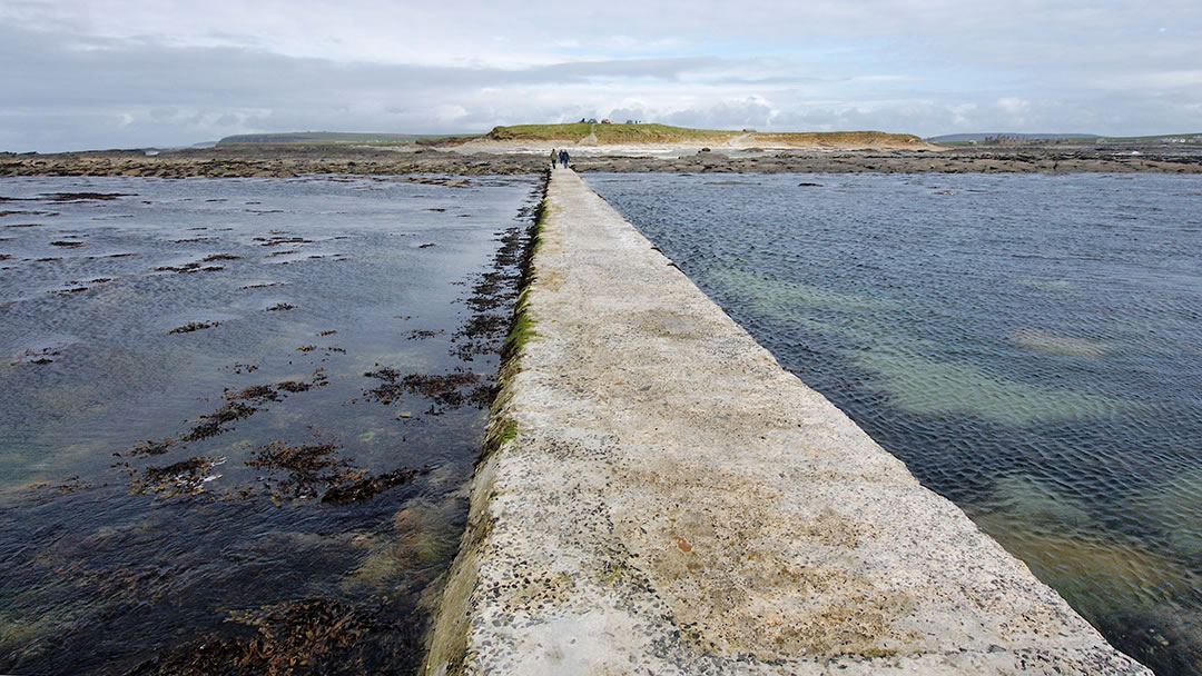
The words 'brough' and 'birsay' both come from the Old Norse 'borg' ('fort'), but their meaning is slightly different. 'Brough' refers to the island's natural defenses. 'Birsay' (formerly byrgisey) means an island accessible only by a narrow spit of land.
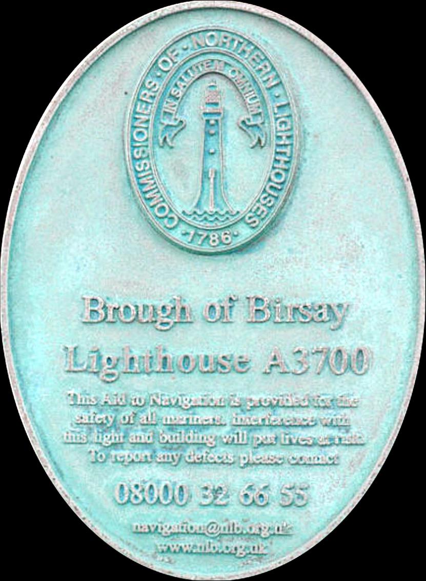
The Brough of Birsay Lighthouse stands on a hill 40 meters above sea level. As a result, the lighthouse did not have to be high to achieve sufficient range. With a tower of 11 meters high, the elevation is 52 meters. The lighthouse marks the northeastern tip of mainland Orkney.
The lighthouse was designed and built in 1925 by David Alan Stevenson engineer at the Northern Lighthouse Board. The lighthouse is built of brick with white plaster, but the design deviates from the general NLB designs. Crenellated walls have been used in this lighthouse. It may be a reference to Kinnaird Head's first lighthouse.
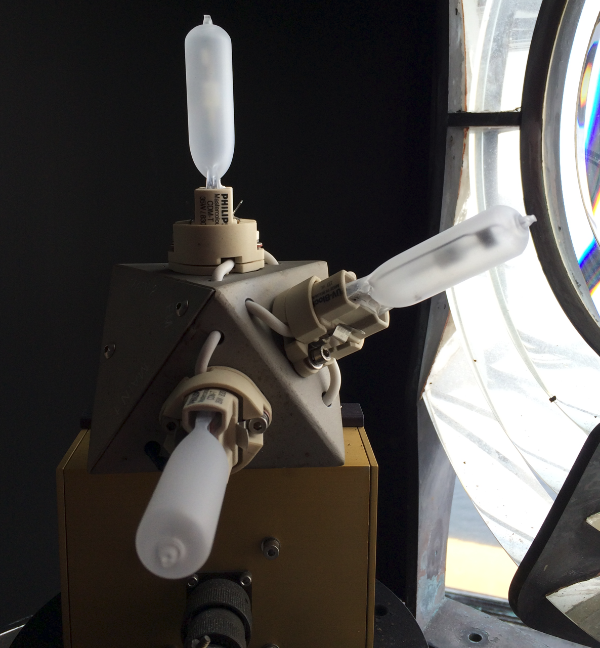
The current lighting system is a 35-watt metal halide lamp with an etched outer glass envelope. There is also a lamp changer. (a lamp changer is used to automatically install a new lamp in the event of a malfunction of the lamp, without human intervention.)
The lighthouse was converted to solar and wind energy in 2002. The light is powered by a series of batteries, which are charged by 36 solar panels and 4 wind turbines. There is also a generator on site to provide backup power for recharging the batteries and daytime installations. The light is controlled automatically, when daylight falls between set levels, a light sensor switches the lighthouse light on and off.
The light is controlled from the Northern Lighthouse Board's headquarters in Edinburgh. Maintenance is carried out once a year when Northern Lighthouse Board technicians visit the lighthouse.

Pictish and Norse societies came into contact on the island of Brough of Birsay. Some Pictish artifacts were found in Norse homes. This may be evidence of peaceful coexistence or they may have been acquired by force.
Between the years 600 and 1200 AD the area was inhabited by the Picts and the Normans on the island.
The Old Norse name for the island was "Byrgisey", meaning fortress island. Brough indeed means fortress. Before Kirkwall became the centre of power in the 12th century, Birsay was the seat of the rulers of Orkney.
The earliest settlement on the island is thought to have been in the 6th century, perhaps by Christian missionaries. In the 7th and 8th centuries it was a significant Pictish fortress, but by the 9th century the Picts had been displaced by Norsemen.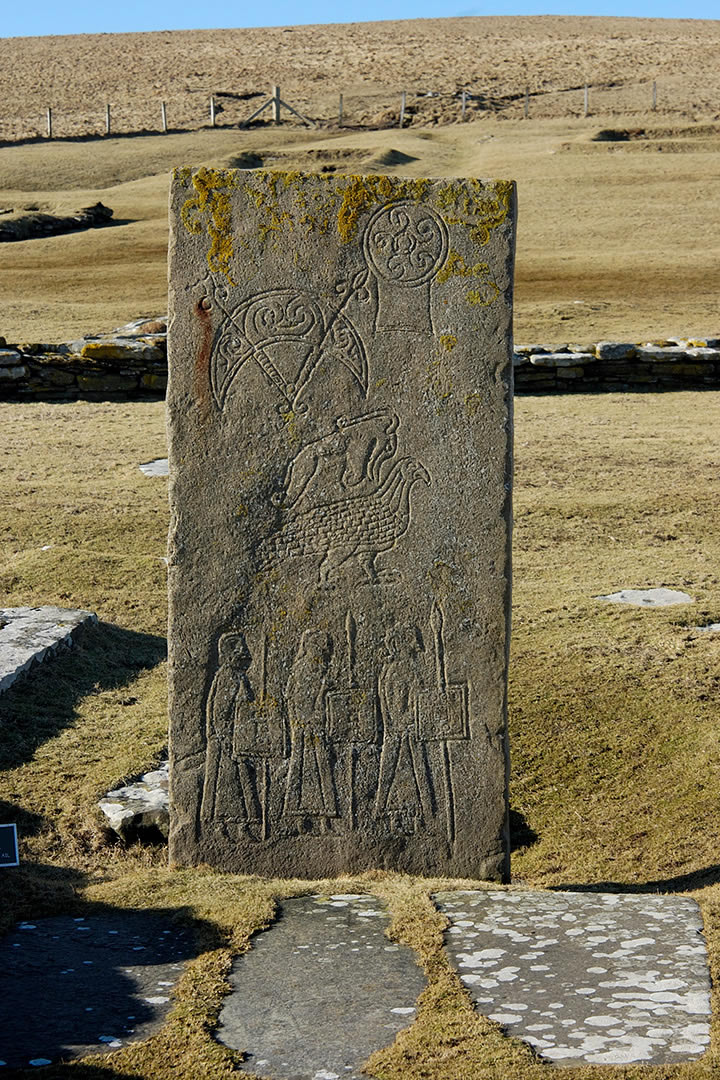
Excavations show that Picts lived here at the end of the 7th century. Today, the most tangible sign of their presence is the symbol stone in the cemetery. (The stone is cast; the original is in the National Museum of Scotland, Edinburgh.) The stone bears four Pictish symbols - mirror case, crescent and V-rod, Pictish beast and eagle - above an unusual scene with three armed men.
The Pictish settlement is evidenced by an important collection of artifacts from a small pit at the eastern end of the churchyard. (now in the Orkney Museum, Kirkwall and in the Museum of Scotland, Edinburgh). Evidence of metalworking was found nearby. High quality items that can be found at Birsay include: brooches, rings, bone combs, dress pins. Traces of Pictish buildings have also been found under the later Viking houses, but these are not visible today.
The wall around the Norse church stands above a Pictish cemetery, and an important Pictish carved stone was found in pieces (also on display in Edinburgh: replica on site). This early eighth-century stone depicts a striking procession of three warriors clad in long robes and carrying spears, swords, and square shields. Above the figures are parts of four Pictish symbols.Norwegian people settled on the island in the early 9th to the 11th century, and the remains of their houses and barns can still be seen. The settlement developed in the course of the next 300 years. By building and renovating, a complicated maze of walls has been created - one to the other - between the later cemetery and the sea.
The Norwegian settlement has partially disappeared by coastal erosion, and the cliffs have been reinforced with concrete upholstery to prevent further damage. There were a number of Norwegian homes, some of which are of considerable size, which indicates great wealth. They include long houses, with both heating and drainage systems and some indications that there were saunas. Although not all houses were in use at the same time, a considerable community lived here. The site, and particularly the objects found there, have been central to debates about the nature of Pictish-Norse relations in Northern Scotland.
The individual rooms of 10th-century houses with underfloor heating are still recognizable. The possible remains of a forge, barn and sauna from the 10th or 11th century and the 12th-century Saint Peter's Church and the accompanying monastery. In the final phase (12th century) a small church and a seemingly monastery were built. Apart from the St. Magnus Cathedral in Kirkwall, this is one of the most refined medieval church buildings that have been preserved on the northern islands.
The Romanesque style church has stone benches along the side walls of the niches of the ship for altars on either side of the entrance of the choir a small monastery, in which the residential buildings are housed in the north. The importance of Birsay as a church center decreased from the 12th century. The monastery was probably short -lived and may never be completed.
Strong wind and salt fever make this a place for strong hardy animal species. Hundreds of seabirds nest on the ridges of the cliffs and were undoubtedly once a source of meat and eggs. Papishions can be seen in the spring and early summer, nesting in caves near the edge of the cliff. There are breeding colonies of the Stormvogel (Fulmarus Glacialis) and Zeekoet (Uria Aalge).